The locations listed on this page currently have less information so do not warrant a page of their own. As this website evolves and more information is added these locations will be promoted to individual pages.

Painscastle
| County | Powys, Wales (11 castles) | Categories | Motte & Bailey |
| Remains | Earthworks only | Access | At any reasonable time |
| Comments | Appears to be freely accessible, but please do not trespass if o private land. | ||
| Location | 52.107817,-3.219177 (Google Maps) | Directions | Directions via Google Maps |
| County |
| Categories |
| Remains |
Earthworks only |
| Access |
At any reasonable time |
| Comments |
Appears to be freely accessible, but please do not trespass if o private land. |
| Location |
| 52.107817,-3.219177 |
| Directions |
| Directions via Google Maps |
Peebles Castle
| County | TBC | Categories | TBC |
| Remains | TBC | Access | TBC - Please check before visiting |
| Location | 55.652,-3.215663 (Google Maps) | Directions | Directions via Google Maps |
| County |
TBC |
| Categories |
TBC |
| Remains |
TBC |
| Access |
TBC - Please check before visiting |
| Location |
| 55.652,-3.215663 |
| Directions |
| Directions via Google Maps |
See Also
Penard Castle
| County | TBC | Categories | TBC |
| Remains | TBC | Access | TBC - Please check before visiting |
| Location | 51.57651,-4.102557 (Google Maps) | Directions | Directions via Google Maps |
| County |
TBC |
| Categories |
TBC |
| Remains |
TBC |
| Access |
TBC - Please check before visiting |
| Location |
| 51.57651,-4.102557 |
| Directions |
| Directions via Google Maps |
See Also
Pencader Castle
 emains of a motte and bailey castle.
| County | Carmathenshire, Wales (7 castles) | Categories | Motte & Bailey |
| Remains | Earthworks only | Access | Unknown - Please check before visiting |
| Location | 52.00237,-4.267 (Google Maps) | Directions | Directions via Google Maps |
| County |
| Categories |
| Remains |
Earthworks only |
| Access |
Unknown - Please check before visiting |
| Location |
| 52.00237,-4.267 |
| Directions |
| Directions via Google Maps |
Pendennis Castle
 endennis Castle was built in around 1540 by King Henry VIII at the entrance to the River Fal at Falmouth. This area known as Carrick Roads is a natural deep water harbour. On the other side of the river's mouth a second castle was built called St. Mawes. Pendennis is built high above the river and is circular in shape with many openings for guns. A low curtain wall surrounds the tower.
 | County | Cornwall (7 castles) | Categories | Henry VIII Gun Fort / Royal castle |
| Remains | Excellent remains | Access | Only open at certain times |
| Location | 50.14722,-5.047777 (Google Maps) ///oldest.curl.engine | Directions | Directions via Google Maps |
| County |
| Categories |
Henry VIII Gun Fort / Royal castle |
| Remains |
Excellent remains |
| Access |
Only open at certain times |
| Location |
| 50.14722,-5.047777 ///oldest.curl.engine |
| Directions |
| Directions via Google Maps |
Timeline
King Henry VIII had a pair of castles built at the mouth of the River Fal near Falmouth in Cornwall. The River mouth is a natural deep water harbour and needed protecting from invasion. These were Pendennis and St. Mawes Castles. [1]
Pendragon Castle
| County | Cumbria, England (6 castles) | Categories | TBC |
| Remains | TBC | Access | TBC - Please check before visiting |
| Location | 54.41837,-2.337449 (Google Maps) | Directions | Directions via Google Maps |
| County |
| Categories |
TBC |
| Remains |
TBC |
| Access |
TBC - Please check before visiting |
| Location |
| 54.41837,-2.337449 |
| Directions |
| Directions via Google Maps |
Penrice Castle
 emains of a large Norman castle with round keep. Located in south Wales a few miles north of Oxwich. Originally of wooden construction the castle was rebuilt in stone during the thirteenth century.
 | County | Swansea, Wales (3 castles) | Categories | Stone |
| Remains | Small amount survives | Access | Unknown - Please check before visiting |
| Comments | The castle now forms part of a private estate with holiday cottage for rent. Access to the castle itself is not known. | ||
| Location | 51.57521,-4.1703 (Google Maps) ///confetti.clotting.interacts | Directions | Directions via Google Maps |
| County |
| Categories |
Stone |
| Remains |
Small amount survives |
| Access |
Unknown - Please check before visiting |
| Comments |
The castle now forms part of a private estate with holiday cottage for rent. Access to the castle itself is not known. |
| Location |
| 51.57521,-4.1703 ///confetti.clotting.interacts |
| Directions |
| Directions via Google Maps |
Location Map (click to explore)
Pentrefoelas Castle
 emains of a motte and bailey castle. On private land. Exact location not known.
| County | Conwy, Wales (6 castles) | Categories | Motte & Bailey |
| Remains | Earthworks only | Access | No Access - Private |
| Location | 53.05552,-3.687425 (Google Maps) | Directions | N/A |
| County |
| Categories |
| Remains |
Earthworks only |
| Access |
No Access - Private |
| Location |
| 53.05552,-3.687425 |
| Directions |
| N/A |
Peveril Castle
 emains of a stone castle situated on a commanding position on the edge of a cliff.
| County | Derbyshire, England (2 castles) | Categories | Stone / Cliff-top |
| Remains | Small amount survives | Access | Only open at certain times |
| Comments | Quote a steep walk from the village to the castle | ||
| Location | 53.33999,-1.777414 (Google Maps) ///expand.users.numeral | Directions | Directions via Google Maps |
| County |
| Categories |
Stone / Cliff-top |
| Remains |
Small amount survives |
| Access |
Only open at certain times |
| Comments |
Quote a steep walk from the village to the castle |
| Location |
| 53.33999,-1.777414 ///expand.users.numeral |
| Directions |
| Directions via Google Maps |
Picton Castlle
 he design of the castle has altered greatly over time so it is not known what the original fortifications consisted of. What exists today is a large rectangular block with four attached round towers and a small double-towered gatehouse. Picton Castle is the successor of the nearby Wiston Castle.
| County | Pembrokeshire, Wales (12 castles) | Categories | Stone / Baronial castle |
| Remains | Not complete but much survives | Access | Only open at certain times |
| Comments | The castle is privately owned and visitors can take a guided tour. See the Picton Castle website for me information. | ||
| Location | 51.784,-4.885 (Google Maps) | Directions | Directions via Google Maps |
| County |
| Categories |
Stone / Baronial castle |
| Remains |
Not complete but much survives |
| Access |
Only open at certain times |
| Comments |
The castle is privately owned and visitors can take a guided tour. See the Picton Castle website for me information. |
| Location |
| 51.784,-4.885 |
| Directions |
| Directions via Google Maps |
Location Map (click to explore)
Piel Castle
| County | Cumbria, England (6 castles) | Categories | Stone |
| Remains | Not complete but much survives | Access | Only open at certain times |
| Location | 54.062217,-3.173408 (Google Maps) | Directions | Directions via Google Maps |
| County |
| Categories |
Stone |
| Remains |
Not complete but much survives |
| Access |
Only open at certain times |
| Location |
| 54.062217,-3.173408 |
| Directions |
| Directions via Google Maps |
Pleshey Castle
 emains of a large motte and bailey castle.
| County | Essex, England (7 castles) | Categories | Motte & Bailey / Stone |
| Remains | Earthworks only | Access | Unknown - Please check before visiting |
| Location | 51.80342,0.414906 (Google Maps) | Directions | Directions via Google Maps |
| County |
| Categories |
Motte & Bailey / Stone |
| Remains |
Earthworks only |
| Access |
Unknown - Please check before visiting |
| Location |
| 51.80342,0.414906 |
| Directions |
| Directions via Google Maps |
Plympton Castle
 emains of a motte and bailey castle.
| County | Devon, England (11 castles) | Categories | Motte & Bailey |
| Remains | Just the motte remains | Access | Unknown - Please check before visiting |
| Location | 50.383679,-4.048382 (Google Maps) | Directions | Directions via Google Maps |
| County |
| Categories |
| Remains |
Just the motte remains |
| Access |
Unknown - Please check before visiting |
| Location |
| 50.383679,-4.048382 |
| Directions |
| Directions via Google Maps |
Location Map (click to explore)
Powerstock Castle
 ossible remains of a motte and bailey castle
| County | Dorset, England (7 castles) | Categories | Motte & Bailey |
| Remains | Earthworks only | Access | Unknown - Please check before visiting |
| Location | 50.76075,-2.680423 (Google Maps) | Directions | Directions via Google Maps |
| County |
| Categories |
| Remains |
Earthworks only |
| Access |
Unknown - Please check before visiting |
| Location |
| 50.76075,-2.680423 |
| Directions |
| Directions via Google Maps |
Powis Castle
 ow a mansion of the site on a medieval castle.
| County | Powys, Wales (11 castles) | Categories | |
| Remains | Excellent remains | Access | Only open at certain times |
| Comments | Now a mansion | ||
| Location | 52.6498,-3.161 (Google Maps) | Directions | Directions via Google Maps |
| County |
| Categories |
| Remains |
Excellent remains |
| Access |
Only open at certain times |
| Comments |
Now a mansion |
| Location |
| 52.6498,-3.161 |
| Directions |
| Directions via Google Maps |
Location Map (click to explore)
Prestatyn Castle
| County | Denbighshire, Wales (5 castles) | Categories | Motte & Bailey |
| Remains | Earthworks only | Access | No Access - Private |
| Location | 53.338498,-3.393605 (Google Maps) | Directions | N/A |
| County |
| Categories |
| Remains |
Earthworks only |
| Access |
No Access - Private |
| Location |
| 53.338498,-3.393605 |
| Directions |
| N/A |
Location Map (click to explore)
Pulford Castle
 emains of a small motte and bailey castle.
| County | Cheshire, England (4 castles) | Categories | Motte & Bailey |
| Remains | Earthworks only | Access | Unknown - Please check before visiting |
| Location | 53.12179,-2.93537 (Google Maps) | Directions | Directions via Google Maps |
| County |
| Categories |
| Remains |
Earthworks only |
| Access |
Unknown - Please check before visiting |
| Location |
| 53.12179,-2.93537 |
| Directions |
| Directions via Google Maps |
Selection of references used:
- 1: John Kinross, Discovering Castles in England and Wales, Shire Publications Ltd
A Medieval Mystery
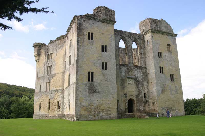
There appear to be some strange connections between the fourteenth century Old Wardour Castle and ancient stone circle Stonehenge.
1: Location
Old Wardour Castle appears to be aligned to ancient sites in the Stonehenge landscape.
2: Alignment
Stonehenge is aligned to the Summer Solstice. Old Wardour has a very similar alignment.
3: Size
Could the builders of Old Wardour used mesaurements from Stonehenge to layout the geometrical keep?
Learn More


