The locations listed on this page currently have less information so do not warrant a page of their own. As this website evolves and more information is added these locations will be promoted to individual pages.

Lanercost Priory
| County | TBC | Categories | TBC |
| Remains | TBC | Access | TBC - Please check before visiting |
| Location | 54.965945,-2.695067 (Google Maps) | Directions | Directions via Google Maps |
| County |
TBC |
| Categories |
TBC |
| Remains |
TBC |
| Access |
TBC - Please check before visiting |
| Location |
| 54.965945,-2.695067 |
| Directions |
| Directions via Google Maps |
See Also
Laugharne Castle
| County | Carmathenshire, Wales (7 castles) | Categories | Stone |
| Remains | Not complete but much survives | Access | At any reasonable time |
| Location | 51.76915,-4.462263 (Google Maps) | Directions | Directions via Google Maps |
| County |
| Categories |
Stone |
| Remains |
Not complete but much survives |
| Access |
At any reasonable time |
| Location |
| 51.76915,-4.462263 |
| Directions |
| Directions via Google Maps |
Location Map (click to explore)
Timeline
Laugharne Castle was the location of one of a series of meetings between King Henry II and Lord Rhys, that confirmed the lands held by the Lord, and where he was given the title of justiciar.
LLawhaden Castle
 Lawhaden Castle, located about ten miles east of Haverfordwest in south Wales, started it's life as a property of the Bishop's of St. Davids. Bishop Thomas of Bek in the reign of King Edward I rebuilt the castle improving its defences. The castle is surrounded by a deep ditch and earth banks. The remains include sections of the twin-towered gate house, parts of the curtain wall and the main hall.
| County | Pembrokeshire, Wales (12 castles) | Categories | Stone |
| Remains | Not complete but much survives | Access | Only open at certain times |
| Location | 51.822344,-4.798 (Google Maps) ///square.twinkled.regulator | Directions | Directions via Google Maps |
| County |
| Categories |
Stone |
| Remains |
Not complete but much survives |
| Access |
Only open at certain times |
| Location |
| 51.822344,-4.798 ///square.twinkled.regulator |
| Directions |
| Directions via Google Maps |
Lulworth Castle
 ot a medieval castle.
| County | Dorset, England (7 castles) | Categories | Baronial castle |
| Remains | Excellent remains | Access | Only open at certain times |
| Comments | A seventeenth century hunting lodge | ||
| Location | 50.63841,-2.206408 (Google Maps) ///hiked.impeached.jubilant | Directions | Directions via Google Maps |
| County |
| Categories |
Baronial castle |
| Remains |
Excellent remains |
| Access |
Only open at certain times |
| Comments |
A seventeenth century hunting lodge |
| Location |
| 50.63841,-2.206408 ///hiked.impeached.jubilant |
| Directions |
| Directions via Google Maps |
Timeline
Henry of Anjou, the future King of England landed on the south coast of England with his uncle Earl Robert of Gloucester and several knights, Henry spent a year in England at Bristol being taught by Master Matthew. Soon after landing in England Earl Robert captured Lulworth Castle, Rufus Castle on Portland and Wareham Castle. [1]
Lydford Castle
 small motte and bailey castle now with a rectangular stone keep on top of the mound.
 | County | Devon, England (11 castles) | Categories | Motte & Bailey / Stone |
| Remains | Small amount survives | Access | At any reasonable time |
| Location | 50.64379,-4.1096 (Google Maps) | Directions | Directions via Google Maps |
| County |
| Categories |
Motte & Bailey / Stone |
| Remains |
Small amount survives |
| Access |
At any reasonable time |
| Location |
| 50.64379,-4.1096 |
| Directions |
| Directions via Google Maps |
Lydney Castle
| County | TBC | Categories | TBC |
| Remains | TBC | Access | TBC - Please check before visiting |
| Location | 51.71991,-2.55583 (Google Maps) | Directions | Directions via Google Maps |
| County |
TBC |
| Categories |
TBC |
| Remains |
TBC |
| Access |
TBC - Please check before visiting |
| Location |
| 51.71991,-2.55583 |
| Directions |
| Directions via Google Maps |
See Also
Selection of references used:
- 1: John Harvey, The Plantagenets
A Medieval Mystery
There appear to be some strange connections between the fourteenth century Old Wardour Castle and ancient stone circle Stonehenge.
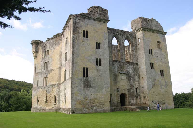
1: Location
Old Wardour Castle appears to be aligned to ancient sites in the Stonehenge landscape.
2: Alignment
Stonehenge is aligned to the Summer Solstice. Old Wardour has a very similar alignment.
3: Size
Could the builders of Old Wardour used mesaurements from Stonehenge to layout the geometrical keep?
Learn More


