 emains of a ringwork castle in Templeton, Pembrokeshire. Possibly the forerunner of Narberth Castle a few miles to the north.
The locations listed on this page currently have less information so do not warrant a page of their own. As this website evolves and more information is added these locations will be promoted to individual pages.

Sentence Castle
 emains of a ringwork castle in Templeton, Pembrokeshire. Possibly the forerunner of Narberth Castle a few miles to the north.
| County | Pembrokeshire, Wales (12 castles) | Categories | |
| Remains | Earthworks only | Access | Unknown - Please check before visiting |
| Comments | Ringwork Castle. | ||
| Location | 51.772794,-4.736548 (Google Maps) | Directions | Directions via Google Maps |
| County |
| Categories |
| Remains |
Earthworks only |
| Access |
Unknown - Please check before visiting |
| Comments |
Ringwork Castle. |
| Location |
| 51.772794,-4.736548 |
| Directions |
| Directions via Google Maps |
Sheriff Hutton Castle
 he village of Sheriff Hutton in North Yorkshire is the location of two castles. The earliest was a motte and bailey castle and its remains are to the south of the church at the east end of the village. A later and larger stone castle was built on the southern side of the village.
| County | North Yorkshire, England (11 castles) | Categories | Motte & Bailey / Stone |
| Remains | Small amount survives | Access | No Access - Private |
| Location | 54.087774,-1.005 (Google Maps) | Directions | N/A |
| County |
| Categories |
Motte & Bailey / Stone |
| Remains |
Small amount survives |
| Access |
No Access - Private |
| Location |
| 54.087774,-1.005 |
| Directions |
| N/A |
See Also
People
Places
- Bolton Castle
- Buttercrambe Castle
- Cawood Castle
- Easby Abbey
- Fountains Abbey
- Helmsley Castle
- Jervaulx Abbey
- Knaresborough Castle
- Middleham Castle
- Pickering Castle
- Richmond Castle
- Rievaulx Abbey
- Ripon Cathedral
- Scarborough Castle
- Whitby Abbey
- York Castle (Clifford's Tower)
- York Minster
- A .. Z List of Medieval Buildings
Skipton Castle
| County | TBC | Categories | TBC |
| Remains | TBC | Access | TBC - Please check before visiting |
| Location | 53.963618,-2.015731 (Google Maps) | Directions | Directions via Google Maps |
| County |
TBC |
| Categories |
TBC |
| Remains |
TBC |
| Access |
TBC - Please check before visiting |
| Location |
| 53.963618,-2.015731 |
| Directions |
| Directions via Google Maps |
See Also
St. Catherine's Castle
| County | Cornwall (7 castles) | Categories | Henry VIII Gun Fort / Royal castle |
| Remains | Not complete but much survives | Access | Only open at certain times |
| Location | 50.328222,-4.644444 (Google Maps) | Directions | Directions via Google Maps |
| County |
| Categories |
Henry VIII Gun Fort / Royal castle |
| Remains |
Not complete but much survives |
| Access |
Only open at certain times |
| Location |
| 50.328222,-4.644444 |
| Directions |
| Directions via Google Maps |
St. Germans Priory
| County | TBC | Categories | TBC |
| Remains | TBC | Access | TBC - Please check before visiting |
| Location | 50.396712,-4.30949 (Google Maps) | Directions | Directions via Google Maps |
| County |
TBC |
| Categories |
TBC |
| Remains |
TBC |
| Access |
TBC - Please check before visiting |
| Location |
| 50.396712,-4.30949 |
| Directions |
| Directions via Google Maps |
See Also
St. Mawes Castle
 t. Mawes Castle was built in around 1540 by King Henry VIII and was one of a pair of castles guarding the entrance to Falmouth harbour. The second castle on the other side of the estuary is Pendennis Castle. St Mawes consists of a large circular tower with three seni-circular towers at its base.
 | County | Cornwall (7 castles) | Categories | Henry VIII Gun Fort / Royal castle |
| Remains | Not complete but much survives | Access | Only open at certain times |
| Comments | The best way to get to this castle is via the ferry as the castle can be seen from the boat. Remember to also visit Pendennis Castle. | ||
| Location | 50.15582,-5.02407 (Google Maps) ///redefined.initial.metro | Directions | Directions via Google Maps |
| County |
| Categories |
Henry VIII Gun Fort / Royal castle |
| Remains |
Not complete but much survives |
| Access |
Only open at certain times |
| Comments |
The best way to get to this castle is via the ferry as the castle can be seen from the boat. Remember to also visit Pendennis Castle. |
| Location |
| 50.15582,-5.02407 ///redefined.initial.metro |
| Directions |
| Directions via Google Maps |
St. Michael's Mount
 he abbey and castle of St. Michael's Mount sit on top of a small island a few hundred metres of the southern coast of Cornwall. The abbey was founded in the mid eleventh century when Benedictine monks from the French abbey of Mont St Michel came to the site. In the time of Richard I the island was captured by Henry de Pomeroy who was a supporter of the future King John. The island was fortified by Pomeroy and again in the late fifteenth century by John de Vere, the Earl of Oxford. de Vere was a supporter of Henry VI and he held the castle for several weeks against attacks from supporters of Edward IV.
| County | Cornwall (7 castles) | Categories | TBC |
| Remains | TBC | Access | TBC - Please check before visiting |
| Location | 50.11709,-5.47779 (Google Maps) ///whizzed.magnitude.greet | Directions | Directions via Google Maps |
| County |
| Categories |
TBC |
| Remains |
TBC |
| Access |
TBC - Please check before visiting |
| Location |
| 50.11709,-5.47779 ///whizzed.magnitude.greet |
| Directions |
| Directions via Google Maps |
Staunton on Arrow Motte
 nly the motte and some earthworks remains are all that is left of this once motte and bailey castle. Overlooks the River Arrow, a tributary of the River Avon.
| County | Herefordshire, England (7 castles) | Categories | Motte & Bailey |
| Remains | Just the motte remains | Access | Unknown - Please check before visiting |
| Comments | Possibly on private land. | ||
| Location | 52.23484,-2.9245 (Google Maps) | Directions | Directions via Google Maps |
| County |
| Categories |
| Remains |
Just the motte remains |
| Access |
Unknown - Please check before visiting |
| Comments |
Possibly on private land. |
| Location |
| 52.23484,-2.9245 |
| Directions |
| Directions via Google Maps |
Stowey Castle
| County | Somerset, England (8 castles) | Categories | TBC |
| Remains | TBC | Access | TBC - Please check before visiting |
| Location | 51.14986,-3.163732 (Google Maps) | Directions | Directions via Google Maps |
| County |
| Categories |
TBC |
| Remains |
TBC |
| Access |
TBC - Please check before visiting |
| Location |
| 51.14986,-3.163732 |
| Directions |
| Directions via Google Maps |
Strensham Castle
| County | Worcestershire, England (6 castles) | Categories | Fortified Manor House / Baronial castle |
| Remains | Earthworks only | Access | Unknown - Please check before visiting |
| Location | 52.06273,-2.14046 (Google Maps) | Directions | Directions via Google Maps |
| County |
| Categories |
Fortified Manor House / Baronial castle |
| Remains |
Earthworks only |
| Access |
Unknown - Please check before visiting |
| Location |
| 52.06273,-2.14046 |
| Directions |
| Directions via Google Maps |
Swerford Castle
 emains of a motte and bailey castle.
| County | Oxfordshire, England (8 castles) | Categories | Motte & Bailey |
| Remains | Earthworks only | Access | Unknown - Please check before visiting |
| Location | 51.97803,-1.46127 (Google Maps) | Directions | Directions via Google Maps |
| County |
| Categories |
| Remains |
Earthworks only |
| Access |
Unknown - Please check before visiting |
| Location |
| 51.97803,-1.46127 |
| Directions |
| Directions via Google Maps |
Swineshead Abbey
 his Cistercian abbey was founded in Lincolnshire by Robert de Greslei. In 1216 King John visited the abbey after losing his baggage train in the Wash Estuary when the tide turned and swept it away. That night the King feasted on fruit and cider and fell ill. Some say that the King was poisoned by a monk from the Abbey. King John was transported to Newark Castle where he died a few days later. Nothing now remains of the abbey.
| County | TBC | Categories | TBC |
| Remains | TBC | Access | TBC - Please check before visiting |
| County |
TBC |
| Categories |
TBC |
| Remains |
TBC |
| Access |
TBC - Please check before visiting |
Timeline
King John died at Newark from excessive eating and drinking. Protestant historians of the 16th century wrote that he was poisoned by a monk at Swineshead in Lincolnshire. The monk received orders from the Pope to kill King John and took a small amount of poisoned wine himself to reassure the King and also died. But had King John become the Pope's ally before his death?
Sycharth Castle
| County | Denbighshire, Wales (5 castles) | Categories | Motte & Bailey / Baronial castle |
| Remains | Earthworks only | Access | At any reasonable time |
| Comments | Would have had a water filled moat. | ||
| Location | 52.824498,-3.180842 (Google Maps) | Directions | Directions via Google Maps |
| County |
| Categories |
Motte & Bailey / Baronial castle |
| Remains |
Earthworks only |
| Access |
At any reasonable time |
| Comments |
Would have had a water filled moat. |
| Location |
| 52.824498,-3.180842 |
| Directions |
| Directions via Google Maps |
A Medieval Mystery
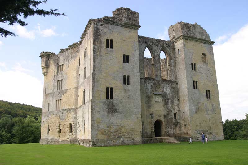
There appear to be some strange connections between the fourteenth century Old Wardour Castle and ancient stone circle Stonehenge.
1: Location
Old Wardour Castle appears to be aligned to ancient sites in the Stonehenge landscape.
2: Alignment
Stonehenge is aligned to the Summer Solstice. Old Wardour has a very similar alignment.
3: Size
Could the builders of Old Wardour used mesaurements from Stonehenge to layout the geometrical keep?
Learn More

